

For most of its life the Ferry crossed the River Avon near the entrance of the Avon Gorge. From the New Inn on the then Somerset side of the river, crossing the River Avon to Rownham Tavern, (demolished in 1873) in Hotwells.
After Hotwells river front was developed in 1873, the ferry moved a little upstream, crossing to Cumberland Basin.
- Rownham Ferry 1596-1610 - from John Speed's - The Counties of Britain
- Bristol Docks 1808 - during the construction of the Floating Harbour
- Bristol from Rownham Ferry 1841/42 by William Henry Bartlett
- Rownham Ferry from Hotwells 1842-1866
- Rownham Ferry 1873 to 1932
- Rownham Ferry Today
- Rownham Ferry on external sites
Rownham Ferry 1596-1610 John Speed's - The Counties of Britain
In John Speed's Tudor atlas: The Counties of Britain mapped between 1596 and 1610. Rownham Ferry at this time is shown as 'Rounam Pafage' on the Somersetshire map and as 'Rownam Pafsage' on the Gloucestershire map.
Rownham Ferry is given the same significance as the then villages of Clifton and Bedminfter (Bedminster) and was plainly an important crossing, I think particularly significant as the first crossing of the River Avon at that time.
Rownham Ferry (or Passage) is shown in the Hartcliff and Bedminster hundred of Somersetshire. The hundred being an administrative subdivision at that time.
John Speed's maps make a colourful and fascinating atlas of well drawn maps that for the time are very accurate, each county or region with a description and often with city maps too. See a zoomable not bad quality online version below -
- Cambridge University: John Speed's Maps

Bristol Docks 1808 during the construction of the Floating Harbour
The New Inn (centre left on photo), on Rownham Ferry's Somerset side and the incomplete Bristol Docks entrance, during the construction of Bristol's Floating Harbour in 1808. Rownham Tavern, in Hotwells may be visible too, I think its the second building upstream from the docks entrance - and roughly central on this photo.
This is a photo of a Bristol Council board (1 of 3) on the landing island at the docks entrance, thats the island shown above but somewhat larger now. The boards celebrates the 200th anniversary of the completion of the Floating Harbour in 2009 and they are well worth a look.
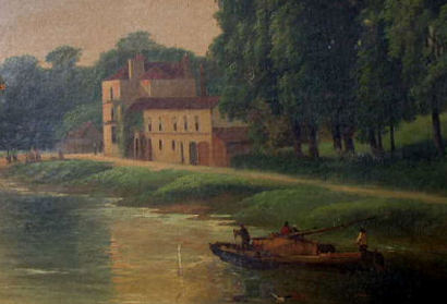
Bristol from Rownham Ferry by William Henry Bartlett 1841/42
Photo at top of page is of Bristol from Rownham Ferry from 1841/2. From a print by the illustrator William Henry Bartlett engraved by S.Bradshaw.

Rownham Ferry from Hotwells
Photos of a painting of Rownham Ferry from Hotwells, my (I hope) informed guess at dates is somewhere between 1842 and 1866.
Its certainly dated before 1873 without the major changes to the Hotwells riverside made in 1873. Also likely to be pre 1866 too as there are no signs of the railway built behind the New Inn (see below) in 1866. Dates are based on Reece Winstone's - Bristol as it was books 1879-1874 and 1874-1866.
Photos courtesy of Cort Day from Los Angeles.

Close ups of Rownham Ferry approaching the New Inn (below) and the Hotwells riverside (left).
The main entrance to Bristol Docks is the inlet visible between the queue and the white signal post/flag pole.
Its pretty busy with queues on both sides of the river.

Rownham Ferry 1873 to 1932
Left, Rownham Ferry in 1913, high tide and a rather busy waterway.
The ferry moved after the expansion of Cumberland Basin in 1873, surviving up to December 31st 1932. With slipways built on the Ashton Meadows and Cumberland Basin sides.
At the lowest tide it was actually a bridge of boats rather than a ferry trip.

I will note my father remembers at least one of the old Rownham Ferry boats still on the riverside during WW2.
Rownham Ferry Today
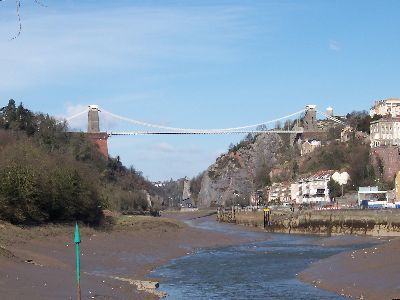
The slipway on the Ashton Meadows (Bower Ashton) side of the Ferry is in the foreground of the photo above, with Brunel's Suspension Bridge spanning the Avon Gorge. Taken from beneath the Avon Bridge.
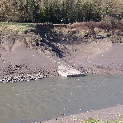
The Rownham Ferry crossing point is now only visible at low tide in Ashton Meadows or from the riverside path beside Brunel Lock Road. The slipway on the Cumberland Basin side is rarely visible and usually completely covered in mud.
More Information from external sites
- Rownham Ferry together with the son of Charles I in 1651 (Charles II in 1660) hiding in the woods nearby, gets a mention in National Gazetteer (1868) - Abbots Leigh. For more on Charles II escape see The Escape of Charles Stuart After Worcester the Stratford to Bristol section.
- Bristol History Online (1661): Ashton to Ashton, West see under Ashton, Long (All Saints Entry). Mention of a chapel and a hermitage at Rounham Ferry.
- The British Museum: The Hot Wells at Bristol from a Meadow, near Rownham Passage - (also showing the New Inn) and likely to be from Ashton Meadow. Not dated but from the use of the name Rownham Passage and the windmill visible (now Clifton Observatory) I am guessing pre 1777. By Paul Sandby, 1730 - 1809).
- Bristol Museum and Art Gallery: Hotwells and Rownham Ferry by William Williams date painted: 1780 - 1789.
- noaa.gov: 11th Feb 1794 "At Rownham Passage, a mile below the city, the ferry-men observed the tide to ebb almost instantaneously, and to sink at least four feet perpendicular. Then it flowed in again, as it should have regularly done."
- Two early large images from the British Library's Online Gallery.
- Rownham Passage on the River Avon - Somersetshire - Artist and Engaver - John Hassell 1797
- View of the Hotwells near Bristol, taken from Rownham Ferry - Engraver - Schumann 1798
- Friends of Bristol Art Gallery 1820: Rownham Ferry by John M Field is no longer online.
Its a watercolour and bodycolour on plaster of paris, showing the New Inn and Rownham Hill from near Freeland Place, Hotwells.
Note that is shows Rownham House (demolished in the 1960's) on the hill side above the New Inn.
- Wikipedia: Francis Danby see the view of the Avon Gorge 1822, from Ashton Meadow.
Its an excellent painting. The changes in tree cover, angle of view, slopes of the hillsides, lack of visible landmarks, building or even the docks entrance make this difficult for me to recognise.
- No photos of Rownham Ferry but two photos from 1831 & 1836 of the Avon Gorge.
See the Ashton Meadows and Hotwells paintings.
Brisray.com: Avon Gorge postcards
- Swansea Museum have a couple of interesting photo's of the crossing by John Dillwyn Llewelyn (Swansea: 1810 to 82).
- Clifton from Rownham Ferry, actually Hotwells and Clifton I think.
- Rownham Ferry from Princes Terrace, Clifton.
- The Victorian Web - Title: Clifton Bridge. In the foreground Rownham Ferry, on the left side the New Inn between 1890-1900.
- c1900 Cumberland Basin. I think this is now mostly beneath Brunel Lock Road as it descends from the raised roadway. The photo shows a view from Cumberland Basin, the man descending (head and shoulders only visible) on the Rownham Ferry slipway, above him on the opposite bank Wellington Cottage.
- 1934 after Rownham Ferry closed in 1932. Flickr: The New Inn (by then the Sunlight Laundry) in 1934
- No online photos available but Reece Winston's 'Bristol as it was' books have many photos of the Ferry.
- The slipways at least may still be in occasional use by The Avon Canoe Pilot